Outback Highway –Queensland | |
|---|---|
 | |
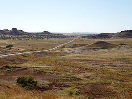
| The Kennedy Development Road between Middleton and Boulia, 2011 | |
| Coordinates | |
| General information | |
| Type | Track |
| Length | 2,719 km (1,690 mi)[1] |
| Major junctions | |
| West end | Laverton Leonora Road Laverton, Western Australia |
| East end | Winton, Queensland |
| Location(s) | |
| Region | Goldfields-Esperance Central Australia Central West Queensland |
| via | Warburton, Yulara, Alice Springs, Boulia |
| Restrictions | |
| Permits | 5 required |
| Fuel supply | Laverton 28°37′27″S 122°23′47″E / 28.624120°S 122.396416°E Tjukayirla Roadhouse 27°09′19″S 124°34′29″E / 27.155334°S 124.574817°E Warburton (26°07′55″S 126°34′08″E / 26.131861°S 126.569026°E Warakurna Roadhouse 25°02′34″S 128°18′12″E / 25.042906°S 128.303417°E Kaltukatjara 24°52′25″S 129°05′00″E / 24.873483°S 129.083220°E Atitjere 22°59′03″S 134°56′08″E / 22.984045°S 134.935457°E Tobermorey Roadhouse 22°16′28″S 137°58′25″E / 22.274469°S 137.973721°E |
| ---- | |
The Outback Highway or Outback Way is a series of roads and dirt tracks linking Laverton, Western Australia and Winton, Queensland. At 2,719 km (1,690 mi), it crosses Central Australia (colloquially known as the Outback), passing through Western Australia, the Northern Territory and Queensland.[2]
- ^ "Outback Highway" (Map). Google Maps. Retrieved 28 May 2022.
- ^ Morris, Nathan (3 October 2016). "The Outback Way: What a sealed road from WA to Queensland will mean for regional communities". ABC News. Australian Broadcasting Corporation. Archived from the original on 3 October 2016. Retrieved 3 October 2016.
