Overlea, Maryland | |
|---|---|
 St. Michael's Church, in October 2010. | |
 right | |
| Coordinates: 39°21′40″N 76°31′10″W / 39.36111°N 76.51944°W | |
| Country | |
| State | |
| County | |
| Area | |
| • Total | 3.02 sq mi (7.81 km2) |
| • Land | 3.02 sq mi (7.81 km2) |
| • Water | 0.00 sq mi (0.00 km2) |
| Elevation | 226 ft (69 m) |
| Population (2020) | |
| • Total | 12,832 |
| • Density | 4,254.64/sq mi (1,642.93/km2) |
| Time zone | UTC−5 (Eastern (EST)) |
| • Summer (DST) | UTC−4 (EDT) |
| FIPS code | 24-59325 |
| GNIS feature ID | 0590957 |
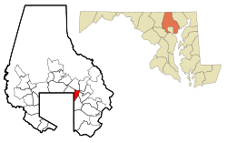
Overlea /ˈoʊvərˌliː/ is an unincorporated community and census-designated place in Baltimore County, Maryland, United States. The population was 12,275 at the 2010 census.[2] Students attend Overlea High School. Area roads include Belair Road (U.S. Route 1) and Kenwood Avenue (Maryland Route 588).
Overlea includes the neighborhood of Fullerton.
- ^ "2020 U.S. Gazetteer Files". United States Census Bureau. Retrieved April 26, 2022.
- ^ "Profile of General Population and Housing Characteristics: 2010 Demographic Profile Data (DP-1): Overlea CDP, Maryland". United States Census Bureau. Retrieved February 29, 2012.