This article needs additional citations for verification. (December 2022) |
Paattinen | |
|---|---|
Former municipality | |
| Paattisten kunta Patis kommun | |
 The village center of Paattinen | |
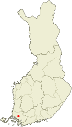
 Location of Paattinen in Finland | |
| Coordinates: 60°35′N 22°23′E / 60.583°N 22.383°E | |
| Country | Finland |
| Province | Turku and Pori Province |
| Region | Finland Proper |
| Established | 1937 |
| Merged into Turku | 1973 |
| Seat | Paattinen |
| Area | |
| • Land | 58.8 km2 (22.7 sq mi) |
| Population (1972-12-31) | |
| • Total | 1,900 |
Paattinen (Finnish: [ˈpɑːtːinen]; Swedish: Patis) is a village in south-west Finland and a district of the city of Turku. It is located to the north of the city, and is the largest of the city's districts by area. It borders the neighbouring municipalities of Vahto, Nousiainen, Mynämäki, Pöytyä, Aura and Lieto. It is rather sparsely populated, and has a population of only 2,430 (as of 2004[update]) despite being much larger than any other of the city's districts. Paattinen has an annual population growth rate of 0.99%.
20.21% of the district's population are under 15 years old, while 15.31% are over 65. The district's linguistic makeup is 98.40% Finnish, 1.03% Swedish, and 0.58% other, making Paattinen one of the most homogeneous districts in Turku.
Paattinen is also a former municipality of Finland. It is the most recent municipality to be annexed to Turku, in 1973.
