This article needs additional citations for verification. (March 2010) |
Palms | |
|---|---|
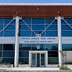
 Palms Station, Los Angeles | |
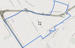
 Palms boundaries as shown on "Mapping L.A." project of the Los Angeles Times | |
| Coordinates: 34°01′23″N 118°24′18″W / 34.023°N 118.405°W | |
| Country | United States |
| State | California |
| County | County of Los Angeles |
| City | City of Los Angeles |
| Government | |
| • City Council | Katy Young Yaroslavsky |
| • State Assembly | Isaac Bryan (D) |
| • State Senate | Lola Smallwood-Cuevas (D) |
| • U.S. House | Ted Lieu (D) |
| Area | |
| • Total | 1.9 sq mi (5 km2) |
| Population (2000)[1] | |
| • Total | 42,545 |
| • Density | 21,983/sq mi (8,488/km2) |
| ZIP Codes | 90034, 90232 |
| Area code(s) | 310/424 |
Palms (originally "The Palms") is a community in the Westside region of Los Angeles, California, founded in 1886 and the oldest neighborhood annexed to the city, in 1915. The 1886 tract was marketed as an agricultural and vacation community.[2] Today it is a primarily residential area, with many apartment buildings, ribbons of commercial zoning and a single-family residential area in its northwest corner. As of the 2000 census the population of Palms was 42,545.[1]
- ^ a b c "Palms Profile – Mapping LA". Los Angeles Times. Retrieved May 9, 2010.
- ^ Garrigues, back cover.
