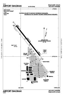
Palo Alto Airport | |||||||||||
|---|---|---|---|---|---|---|---|---|---|---|---|
 Aerial view of Palo Alto Airport | |||||||||||
| Summary | |||||||||||
| Airport type | Public | ||||||||||
| Operator | City of Palo Alto | ||||||||||
| Serves | San Francisco Bay Area | ||||||||||
| Location | Palo Alto, California, U.S. | ||||||||||
| Elevation AMSL | 7 ft / 2 m | ||||||||||
| Coordinates | 37°27′40″N 122°06′54″W / 37.46111°N 122.11500°W | ||||||||||
| Website | Official website | ||||||||||
| Map | |||||||||||
 | |||||||||||
| Runways | |||||||||||
| |||||||||||
| Statistics | |||||||||||
| |||||||||||

Palo Alto Airport (IATA: PAO, ICAO: KPAO, FAA LID: PAO) is a general aviation airport in the city of Palo Alto in Santa Clara County, California, United States, near the south end of San Francisco Bay on the western shore.[1]