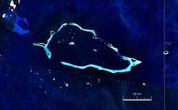
 Satellite image of Conflict Group atoll. | |
 Panasesa Island on Conflict Group atoll map. | |
| Geography | |
|---|---|
| Location | Oceania |
| Coordinates | 10°44′24″S 151°43′30″E / 10.74000°S 151.72500°E |
| Archipelago | Louisiade Archipelago |
| Adjacent to | Solomon Sea |
| Total islands | 1 |
| Area | 0.66 km2 (0.25 sq mi) |
| Length | 1.2 km (0.75 mi) |
| Width | 1 km (0.6 mi) |
| Highest elevation | 8 m (26 ft) |
| Highest point | 18 |
| Administration | |
| Province | |
| District | Samarai-Murua District |
| LLG | Bwanabwana Rural LLG |
| Island Group | Calvados Chain |
| Largest settlement | Irai (pop. 20) |
| Additional information | |
| Time zone | |
| ISO code | PG-MBA |
| Official website | www |
Panasesa Island is located in Milne Bay Province, Papua New Guinea, 500 km to the east of Port Moresby, the nation's capital. Panasesa Island has an eco resort with small staff.[1]
- ^ John Huxley What it’s like touring rich-lister Ian Gowrie-Smith’s private paradise, the Conflict Islands in PNG Escape, June 29, 2014
