Pangani District
Wilaya ya Pangani (Swahili) | |
|---|---|
|
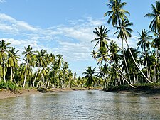
From top to bottom: Coconuts in Pangani River delta in Bushiri ward of Pangani District, historic Pangani town & Funguni reef sandbank in Pangani District | |
| Nickname: Tanga's paradise | |
 Pangani District in Tanga | |
| Coordinates: 5°34′36″S 38°50′26″E / 5.57667°S 38.84056°E | |
| Country | |
| Region | Tanga Region |
| Named for | Pangani River |
| Capital | Pangani Mashariki |
| Area | |
| • Total | 1,756 km2 (678 sq mi) |
| • Rank | 8th in Tanga |
| Population (2022) | |
| • Total | 75,642 |
| • Rank | 6th in Tanga |
| • Density | 43/km2 (110/sq mi) |
| Ethnic groups | |
| • Settler | Swahili, Makonde, Bena, Arab and Indian |
| • Native | Bondei & Zigua |
| Time zone | UTC+3 (EAT) |
| Tanzanian Postcode | 213 |
| Website | Official website |
| Symbols of Tanzania | |
| Bird |  |
| Fish | |
| Mammal | |
Pangani District Council (Wilaya ya Pangani, in Swahili) is one of eleven administrative districts of Tanga Region in Tanzania. The District covers an area of 1,756 km2 (678 sq mi).[1] It is bordered to the north by Muheza District, to the east by Zanzibar Channel, to the south by the Chalinze District of Pwani Region, and to the west by the Handeni District. The district is comparable in size to the land area of Guadeloupe.[2] The district seat (capital) and largest settlement in Pangani district is the town of Pangani. The district is named after the historic Pangani River. As of the 2022 census, the population was Pangani district was 75,642, making it the least populous district in Tanga Region.[3][4]
- ^ "Tanzania: Northern Zone(Districts and Wards) - Population Statistics, Charts and Map".
- ^ 1,630 km2 (630 sq mi) for Guadeloupe at "Area size comparison". Nation master. 2022. Retrieved 25 July 2023.
- ^ "Tanzania: Administrative Division (Regions and Districts) - Population Statistics, Charts and Map". www.citypopulation.de. Retrieved 2024-02-11.
- ^ "2012 Population and Housing Census" (PDF). Development Partners Group Tanzania. Retrieved 7 August 2019.


