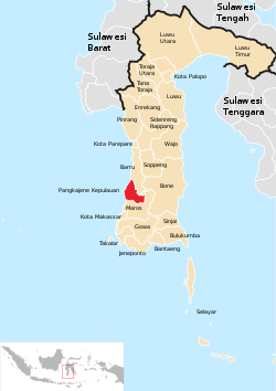
Pangkajene & Islands Regency
Kabupaten Pangkajene dan Kepulauan | |
|---|---|
 View from Bulu Sorongan | |
 Location within South Sulawesi | |
| Coordinates: 4°45′S 119°30′E / 4.750°S 119.500°E | |
| Country | |
| Province | |
| Capital | Pangkajene |
| Area | |
| • Total | 1,112.29 km2 (429.46 sq mi) |
| Population (mid 2023 estimate)[1] | |
| • Total | 357,846 |
| • Density | 320/km2 (830/sq mi) |
| Time zone | UTC+8 (WITA) |
| Area code | (+62) 410 |
| Website | pangkepkab |


The Pangkajene and Islands Regency (Indonesian: Kabupaten Pangkajene dan Kepulauan, usually shortened to Pangkep), (Makasar: ᨈᨀᨒᨑ, romanized: Pangkajè’ne’, Makasar pronunciation: [paŋkaˈɟeʔnɛʔ]) is a regency of South Sulawesi province of Indonesia. The regency lies primarily on the mainland of Sulawesi's southern peninsula, but also includes the Spermonde Islands (Kepulauan Spermonde) off the west coast of that peninsula, as well as other small islands further west and southwest. The principal town, Pangkajene, lies on Sulawesi, but there is a series of further small towns like Lejang, Labakkang, Bonto-Bonto and Segeri proceeding northwards from Pangkajene along the Trans-Sulawesi Highway. The total land area is 1,112.29 km2, and the population was 305,737 at the 2010 Census[2] and 345,775 at the 2020 Census;[3] the official population estimate as of mid-2023 was 357,846 (comprising 175,700 males and 182,146 females).[1]


