This article needs additional citations for verification. (April 2011) |
| Panhandle | |
|---|---|
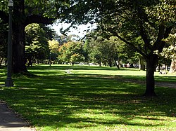
 The Panhandle from Clayton Street | |
 | |
| Type | Municipal (San Francisco) |
| Location | San Francisco |
| Created | 1870 |
| Status | Open all year |
| Parking | Street parking |
The Panhandle is a public park in San Francisco, California, so named because it forms a panhandle with Golden Gate Park. It is long and narrow, being three-quarters of a mile (eight blocks) long and just one block wide. Fell and Oak Streets border it to the north and south, Baker Street to the east, and to the west Stanyan Street which separates the smaller Panhandle from the much larger Golden Gate Park. The Panhandle is bisected by Masonic Avenue, which runs north to south and cuts through the middle of the park. In its westernmost block, Oak and Fell Streets angle across the Panhandle, converge with one another, and continue west of Stanyan as John F. Kennedy Drive and Kezar Drive.
Two paved walking paths, one allowing bicycles, run the entire length of the Panhandle from east to west, and several shorter ones criss-cross it north to south. In its western section, between Stanyan and Masonic, the Panhandle contains basketball courts,[1] a public restroom, a playground, and an outdoor gym. The William McKinley Memorial is at the eastern end of the Panhandle, just across Baker Street from the DMV; it consists of a statue and seating area, and was dedicated in 1904 by President Theodore Roosevelt, who succeeded McKinley after his assassination in 1901.[2]
The Panhandle forms the southern boundary of the Western Addition neighborhood and the northern boundary of the Haight-Ashbury district.
- ^ "Court profile of Panhandle basketball court". courtsoftheworld.com.
- ^ "McKinley Memorial, (sculpture)". Smithsonian Institution. Retrieved January 4, 2022.