| Pannawonica Western Australia | |||||||||
|---|---|---|---|---|---|---|---|---|---|
 | |||||||||
 | |||||||||
| Coordinates | 21°38′00″S 116°20′00″E / 21.63333°S 116.33333°E | ||||||||
| Population | 685 (SAL 2021)[1][2] | ||||||||
| Established | 1970 | ||||||||
| Postcode(s) | 6716 | ||||||||
| Elevation | 200 m (656 ft) | ||||||||
| Area | 27.6 km2 (10.7 sq mi) | ||||||||
| Location | |||||||||
| LGA(s) | Shire of Ashburton | ||||||||
| State electorate(s) | North West Central | ||||||||
| Federal division(s) | Durack | ||||||||
| |||||||||
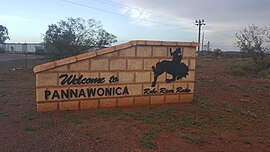
Pannawonica is an iron-ore mining town located in the Pilbara region of Western Australia, near the Robe River, about 200 km (120 mi) south-west from Karratha and 1,429 km (888 mi) North from Perth. At the 2016 census, Pannawonica had a population of 695.[3]
In 2011 and again in 2016, it reportedly had the highest median weekly income of any town in Western Australia and most likely Australia, due to the high income of its mine workers.[4]
- ^ Australian Bureau of Statistics (28 June 2022). "Pannawonica (suburb and locality)". Australian Census 2021 QuickStats. Retrieved 28 June 2022.
- ^ Australian Bureau of Statistics (28 June 2022). "Pannawonica (suburb and locality)". Australian Census 2021.
- ^ "2016 Census QuickStats: Pannawonica". censusdata.abs.gov.au. Retrieved 17 May 2018.
- ^ Salt B Richest and poorest live in outback towns The Australian Business, 27 November 2008
