Pantabangan | |
|---|---|
| Municipality of Pantabangan | |
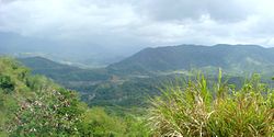
 Mountains in Pantabangan | |
 Map of Nueva Ecija with Pantabangan highlighted | |
Location within the Philippines | |
| Coordinates: 15°48′31″N 121°08′36″E / 15.8086°N 121.1433°E | |
| Country | Philippines |
| Region | Central Luzon |
| Province | Nueva Ecija |
| District | 2nd district |
| Founded | 1701 |
| Barangays | 14 (see Barangays) |
| Government | |
| • Type | Sangguniang Bayan |
| • Mayor | Roberto T. Agdipa |
| • Vice Mayor | Monaliza H. Agdipa |
| • Representative | Micaela S. Violago |
| • Municipal Council | Members |
| • Electorate | 27,784 voters (2022) |
| Area | |
| • Total | 392.56 km2 (151.57 sq mi) |
| Elevation | 260 m (850 ft) |
| Highest elevation | 547 m (1,795 ft) |
| Lowest elevation | 107 m (351 ft) |
| Population (2020 census)[3] | |
| • Total | 31,763 |
| • Density | 81/km2 (210/sq mi) |
| • Households | 7,213 |
| Economy | |
| • Income class | 1st municipal income class |
| • Poverty incidence | 19.66 |
| • Revenue | ₱ 283.1 million (2020) |
| • Assets | ₱ 1,486 million (2020) |
| • Expenditure | ₱ 253.4 million (2020) |
| • Liabilities | ₱ 516.6 million (2020) |
| Service provider | |
| • Electricity | Pantabangan Municipal Electric System (PAMES) |
| Time zone | UTC+8 (PST) |
| ZIP code | 3124 |
| PSGC | |
| IDD : area code | +63 (0)44 |
| Native languages | Ilocano Tagalog |
Pantabangan, officially the Municipality of Pantabangan, is a 1st class municipality in the province of Nueva Ecija, Philippines. According to the 2020 census, it has a population of 31,763 people.[3]
This is the site of the Pantabangan Dam and Lake.
Located in the northern part of Nueva Ecija, Pantabangan is located at the foot of Mt. Mabilog below Mt. Dalimanok which are found between Sierra Madre and Caraballo Mountain ranges. It is home to the Pantabangan–Carranglan Watershed Forest Reserve.
Pantabangan is 51 kilometres (32 mi) from Cabanatuan, 65 kilometres (40 mi) from Palayan, 167 kilometres (104 mi) from Manila, and 139 kilometres (86 mi) from Bayombong.
- ^ Municipality of Pantabangan | (DILG)
- ^ "2015 Census of Population, Report No. 3 – Population, Land Area, and Population Density" (PDF). Philippine Statistics Authority. Quezon City, Philippines. August 2016. ISSN 0117-1453. Archived (PDF) from the original on May 25, 2021. Retrieved July 16, 2021.
- ^ a b Census of Population (2020). "Region III (Central Luzon)". Total Population by Province, City, Municipality and Barangay. Philippine Statistics Authority. Retrieved 8 July 2021.
- ^ "PSA Releases the 2021 City and Municipal Level Poverty Estimates". Philippine Statistics Authority. 2 April 2024. Retrieved 28 April 2024.


