Panthersville, Georgia | |
|---|---|
 The Barack H. Obama Elementary Magnet School of Technology in Panthersville | |
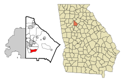
 Location in DeKalb County and the state of Georgia | |
| Coordinates: 33°42′20″N 84°16′43″W / 33.70556°N 84.27861°W | |
| Country | United States |
| State | Georgia |
| County | DeKalb |
| Area | |
| • Total | 3.69 sq mi (9.55 km2) |
| • Land | 3.67 sq mi (9.50 km2) |
| • Water | 0.02 sq mi (0.05 km2) |
| Elevation | 889 ft (271 m) |
| Population (2020) | |
| • Total | 11,237 |
| • Density | 3,064.36/sq mi (1,183.14/km2) |
| Time zone | UTC-5 (Eastern (EST)) |
| • Summer (DST) | UTC-4 (EDT) |
| FIPS code | 13-59080[2] |
| GNIS feature ID | 0332600[3] |

Panthersville is an unincorporated community and census-designated place (CDP) in DeKalb County, Georgia, United States. The population was 11,237 in 2020, up from 9,749 in 2010.
- ^ "2020 U.S. Gazetteer Files". United States Census Bureau. Retrieved December 18, 2021.
- ^ "U.S. Census website". United States Census Bureau. Retrieved January 31, 2008.
- ^ "US Board on Geographic Names". United States Geological Survey. October 25, 2007. Retrieved January 31, 2008.
