| Panwali Dwar | |
|---|---|
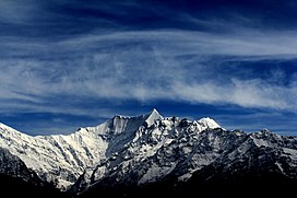
 Panwali Dwar and Nanda Khat from Chiltha Mai near Dhakuri top | |
| Highest point | |
| Elevation | 6,663 m (21,860 ft)[1] |
| Prominence | 763 m (2,503 ft)[2] |
| Listing | Mountains of Uttarakhand |
| Coordinates | 30°17′22″N 79°57′21″E / 30.28944°N 79.95583°E |
| Geography | |
| Location | Bageshwar district, Uttarakhand, India |
| Parent range | Kumaun Himalayas |
| Climbing | |
| First ascent | A Japanese team climbed it in 1980[3] |
Panwali Dwar is a mountain of the Kumaun Himalayas located in the Bageshwar district of Uttarakhand, India. The elevation of Panwali Dwar is 6,683 metres (21,926 ft) and its prominence is 763 metres (2,503 ft). It is 55th highest located entirely within the Uttarakhand. Nanda Devi, is the highest mountain in this category. It lies on southern wall of Nanda devi sanctuary. Its nearest higher neighbor Maiktoli 6,803 metres (22,320 ft) lies 8.2 km WSW. It is located 2.6 km SW of Nanda Khat 6,611 metres (21,690 ft) and 9.2 km NE lies Nanda Devi East 7,434 metres (24,390 ft).
- ^ "Panwali Dwar". Peakware.com. Archived from the original on 2016-03-04. Retrieved 12 May 2020.
- ^ "Panwali Dwar". PeakVisor. Retrieved 12 May 2020.
- ^ Cite error: The named reference
Kapadia1999was invoked but never defined (see the help page).
