| Pardee Dam | |
|---|---|
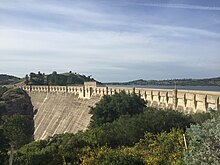
 View of the Pardee Dam from downstream. | |
| Location | Sierra Nevada Foothills Amador County, California Calaveras County, California |
| Coordinates | 38°15′27″N 120°51′01″W / 38.2574°N 120.8502°W |
| Opening date | 1929 |
| Operator(s) | East Bay Municipal Utility District |
| Dam and spillways | |
| Impounds | Mokelumne River |
| Height | 345 ft (105 m) |
| Length | 1,337 ft (408 m) |
| Reservoir | |
| Creates | Pardee Reservoir |
| Total capacity | 210,000 acre⋅ft (260,000,000 m3) |
| Catchment area | 575 sq mi (1,490 km2) |
| Surface area | 2,134 acres (864 ha) |
| Power Station | |
| Installed capacity | 23.6 MW |
| Annual generation | 99,038,000 KWh (2001–2012)[1] |
| U.S. Geological Survey Geographic Names Information System: Pardee Dam | |
| Pardee Dam bridge | |
|---|---|
| Carries | Pardee Dam Road |
| Characteristics | |
| Width | 16 ft (4.9 m) |
Pardee Dam is a 345-foot (105 m)-high structure across the Mokelumne River which marks the boundary between Amador and Calaveras Counties, located in the foothills of the Sierra Nevada approximately 30 miles (48 km) northeast of Stockton.
- ^ "California Hydroelectric Statistics & Data". California Energy Commission. Archived from the original on 2018-02-26. Retrieved 2018-04-26.