City of Parlier | |
|---|---|
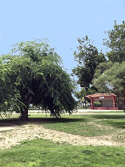
 Earl Ruth Park | |
 Location in Fresno County and the state of California | |
| Coordinates: 36°36′42″N 119°31′37″W / 36.61167°N 119.52694°W[1] | |
| Country | |
| State | |
| County | Fresno |
| Incorporated | November 15, 1921[2] |
| Government | |
| • State Senator | Anna Caballero (D)[3] |
| • Assemblymember | Joaquin Arambula (D)[4] |
| • U. S. Rep. | Jim Costa (D)[5] |
| Area | |
| • Total | 2.41 sq mi (6.24 km2) |
| • Land | 2.41 sq mi (6.24 km2) |
| • Water | 0.00 sq mi (0.00 km2) 0% |
| Elevation | 344 ft (105 m) |
| Population (2020) | |
| • Total | 18,494 |
| • Density | 6,483.19/sq mi (2,503.53/km2) |
| Time zone | UTC-8 (PST) |
| • Summer (DST) | UTC-7 (PDT) |
| ZIP code | 93648 |
| Area code | 559 |
| FIPS code | 06-55856 |
| GNIS feature IDs | 1659348, 2411376 |
| Website | www |
Parlier is a city in Fresno County, California, United States. As of the 2020 census, the city had a total population of 18,494, up from 14,494 in 2010. The city has one of the state's highest percentage of Latinos, a large majority of whom are seasonal migrant laborers who arrive and temporarily work in the area's agricultural sector. Parlier is located 5.5 miles (9 km) east-northeast of Selma,[7] at an elevation of 344 feet (105 m).[1]
- ^ a b c "Parlier". Geographic Names Information System. United States Geological Survey, United States Department of the Interior.
- ^ "California Cities by Incorporation Date". California Association of Local Agency Formation Commissions. Archived from the original (Word) on November 3, 2014. Retrieved April 6, 2013.
- ^ "Senators". State of California. Retrieved April 6, 2013.
- ^ "Members Assembly". State of California. Retrieved April 6, 2013.
- ^ "California's 21st Congressional District - Representatives & District Map". Civic Impulse, LLC. Retrieved April 6, 2013.
- ^ "2019 U.S. Gazetteer Files". United States Census Bureau. Retrieved July 1, 2020.
- ^ Durham, David L. (1998). California's Geographic Names: A Gazetteer of Historic and Modern Names of the State. Clovis, Calif.: Word Dancer Press. p. 1086. ISBN 1-884995-14-4.

