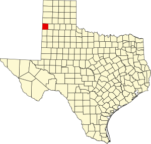
Parmer County | |
|---|---|
 The Parmer County Courthouse in Farwell | |
 Location within the U.S. state of Texas | |
 Texas's location within the U.S. | |
| Coordinates: 34°32′N 102°47′W / 34.53°N 102.78°W | |
| Country | |
| State | |
| Founded | 1907 |
| Named for | Martin Parmer |
| Seat | Farwell |
| Largest city | Friona |
| Area | |
| • Total | 885 sq mi (2,290 km2) |
| • Land | 881 sq mi (2,280 km2) |
| • Water | 4.4 sq mi (11 km2) 0.5% |
| Population (2020) | |
| • Total | 9,869 |
| • Density | 11/sq mi (4/km2) |
| Time zone | UTC−6 (Central) |
| • Summer (DST) | UTC−5 (CDT) |
| Congressional district | 19th |
| Website | parmercounty |
Parmer County is a county located in the southwestern Texas Panhandle on the High Plains of the Llano Estacado in the U.S. state of Texas. As of the 2020 Census, the population was 9,869.[1] The county seat is Farwell.[2] The county was created in 1876 and later organized in 1907.[3] It is named in honor of Martin Parmer, a signer of the Texas Declaration of Independence and early judge. Parmer County was one of 10[4] prohibition, or entirely dry, counties in the state of Texas, but is now a wet county.
- ^ "Parmer County, Texas". United States Census Bureau. Retrieved February 23, 2021.
- ^ "Find a County". National Association of Counties. Archived from the original on May 31, 2011. Retrieved June 7, 2011.
- ^ "Texas: Individual County Chronologies". Texas Atlas of Historical County Boundaries. The Newberry Library. 2008. Retrieved May 26, 2015.
- ^ "TABC Local Option Elections". Retrieved May 3, 2014.