Paroa | |
|---|---|
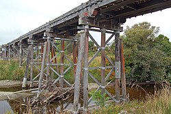
 Paroa Trestle on the old Hokitika Branch line | |
 | |
| Coordinates: 42°30′39″S 171°10′9″E / 42.51083°S 171.16917°E | |
| Country | New Zealand |
| Region | West Coast |
| District | Grey District |
| Ward | Southern |
| Electorates | |
| Government | |
| • Territorial Authority | Grey District Council |
| • Regional council | West Coast Regional Council |
| • Mayor of Grey | Tania Gibson |
| • West Coast-Tasman MP | Maureen Pugh |
| • Te Tai Tonga MP | Tākuta Ferris |
| Area | |
• Total | 12.12 km2 (4.68 sq mi) |
| Population (June 2024)[2] | |
• Total | 1,510 |
| • Density | 120/km2 (320/sq mi) |
| Local iwi | Ngāi Tahu |
Paroa is a settlement on the West Coast of the South Island of New Zealand, just south of Greymouth. State Highway 6 and the Hokitika Branch railway both run through Paroa.[3][4] This railway was originally a bush tramway that opened to Paroa from Greymouth in 1867 and was extended to Kumara in 1877.[5] It was converted into a railway in 1893, and this time, ran from Paroa to Hokitika rather than Kumara.[6]
The New Zealand Ministry for Culture and Heritage gives a translation of "broad fortified village" for Pāroa.[7]
Shantytown, to the south-east of Paroa, is a recreation of a typical 1880s West Coast gold mining town, built in 1971 and operating as a commercial tourist attraction.[8]
- ^ Cite error: The named reference
Areawas invoked but never defined (see the help page). - ^ "Aotearoa Data Explorer". Statistics New Zealand. Retrieved 26 October 2024.
- ^ Peter Dowling, ed. (2004). Reed New Zealand Atlas. Reed Books. pp. map 69. ISBN 0-7900-0952-8.
- ^ Roger Smith, GeographX (2005). The Geographic Atlas of New Zealand. Robbie Burton. pp. map 156. ISBN 1-877333-20-4.
- ^ "Kumara, Westland". Encyclopedia of New Zealand (1966).
- ^ "Hokitika-Grey railway". No. 9537. West Coast Times. 25 May 1893. p. 2.
- ^ "1000 Māori place names". New Zealand Ministry for Culture and Heritage. 6 August 2019.
- ^ "History of Shantytown". Archived from the original on 24 February 2008. Retrieved 29 July 2008.