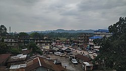
Pasighat | |
|---|---|
Town | |
 A view of Pasighat from Hotel Siang | |
| Coordinates: 28°04′N 95°20′E / 28.07°N 95.33°E | |
| Country | |
| State | Arunachal Pradesh |
| District | East Siang |
| Government | |
| • Type | Multi Party democracy |
| • Deputy Commissioner | Mr. Tayi Taggu, IAS |
| Area | |
| • Total | 14.60 km2 (5.64 sq mi) |
| Elevation | 152 m (499 ft) |
| Population (2011)[1] | |
| • Total | 24,656 |
| • Density | 1,504.9/km2 (3,898/sq mi) |
| Languages[2][3] | |
| • Official | |
| Time zone | UTC+5:30 (IST) |
| PIN | 791102 |
| Telephone code | 0368 |
| ISO 3166 code | IN-AR |
| Vehicle registration | AR-09 |
| Climate | Cwa |
| Website | www |
Pasighat is the headquarters of East Siang district in the Indian state of Arunachal Pradesh. Situated at the eastern foothills of the Himalayas at 155 metres (509 ft) above mean sea level, Pasighat is Arunachal's oldest town.[4] The Government of India included Pasighat in the Smart Cities Mission development scheme in June 2017.
It is also an Advance Landing Ground (ALG) of Indian Air Force.
- ^ "Census of India Search details". censusindia.gov.in. Retrieved 10 May 2015.
- ^ "1977 Sikkim government gazette" (PDF). sikkim.gov.in. Governor of Sikkim. p. 188. Archived from the original (PDF) on 22 July 2018. Retrieved 28 May 2019.
- ^ "50th Report of the Commissioner for Linguistic Minorities in India" (PDF). 16 July 2014. p. 109. Archived from the original (PDF) on 2 January 2018. Retrieved 28 May 2019.
- ^ Pasighat: Oldest town of Arunachal Pradesh Archived 26 January 2011 at the Wayback Machine. All India Radio.

