Pasir Mas District
Pase Mah | |
|---|---|
| Jajahan Pasir Mas | |
| Other transcription(s) | |
| • Jawi | ڤاسير مس |
| • Chinese | 巴西马县 |
| • Tamil | பாசிர் மாஸ் |
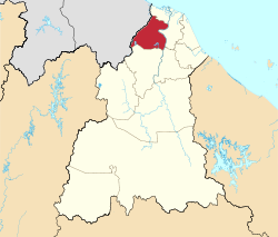
 Location of Pasir Mas District in Kelantan | |
 | |
Location of Pasir Mas District in Malaysia | |
| Coordinates: 6°2′N 102°8′E / 6.033°N 102.133°E | |
| Country | |
| State | |
| Seat | Pasir Mas |
| Local area government(s) | Pasir Mas District Council |
| Government | |
| • District officer | Hazmi Bin Abdul Hamid[1] |
| • Administrative office | Pasir Mas District and Land Office |
| Area | |
| • Total | 570 km2 (220 sq mi) |
| Population (2022)[3] | |
| • Total | 233,400 |
| • Density | 410/km2 (1,100/sq mi) |
| Time zone | UTC+8 (MST) |
| • Summer (DST) | UTC+8 (Not observed) |
| Postcode | 17xxx |
| Calling code | +6-09 |
| Vehicle registration plates | D |
Pasir Mas District is a district (jajahan) in Kelantan, Malaysia. The district covers an area of 614.15 square kilometers and is bordered by the districts of Tumpat District to the north, Tanah Merah District to the south, Kota Bharu District to the east, and the Thai district of Su-ngai Kolok (Malay: Sungai Golok) to the west.[2]
Due to its geographical location, it acts as the main gateway of the East Coast of Malaysia to Thailand and is also traversed by major road transport routes from the West Coast to the state capital of Kota Bharu.
The district of Pasir Mas was originally part of the district of Kota Bharu. In 1918, the town of Pasir Mas and its surrounding areas were separated from Kota Bharu and granted its own local government. The seat of this district is the town of Pasir Mas.
- ^ "Perutusan Ketua Jajahan". www.ptjpm.kelantan.gov.my. Retrieved 2022-09-09.
- ^ a b "Laman Web Rasmi - Pejabat Tanah Dan Jajahan Pasir Mas - Sejarah Jabatan". www.ptjpm.kelantan.gov.my. Archived from the original on 2019-03-07. Retrieved 2017-11-27.
- ^ "Population Distribution and Basic Demographic Characteristics, 2010" (PDF). Department of Statistics, Malaysia. Archived from the original (PDF) on 22 May 2014. Retrieved 19 April 2012.

