Pasquotank County | |
|---|---|
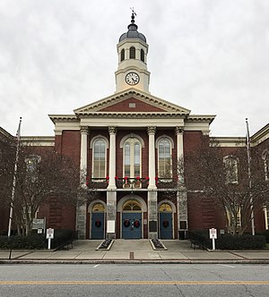
 Pasquotank County Courthouse | |
 Location within the U.S. state of North Carolina | |
 North Carolina's location within the U.S. | |
| Coordinates: 36°16′N 76°16′W / 36.27°N 76.26°W | |
| Country | |
| State | |
| Founded | 1668 |
| Named for | Indian word meaning "where the current of the stream divides or forks"[1] |
| Seat | Elizabeth City |
| Largest community | Elizabeth City |
| Area | |
| • Total | 289.33 sq mi (749.4 km2) |
| • Land | 226.88 sq mi (587.6 km2) |
| • Water | 62.45 sq mi (161.7 km2) 21.58% |
| Population (2020) | |
| • Total | 40,568 |
| • Estimate (2023) | 41,444 |
| • Density | 178.81/sq mi (69.04/km2) |
| Time zone | UTC−5 (Eastern) |
| • Summer (DST) | UTC−4 (EDT) |
| Congressional district | 1st |
| Website | www |
Pasquotank County (PAS-kwoh-tayngk /ˈpæs.kwoʊ.teɪŋk/ )[2] is a county located in the U.S. state of North Carolina. As of the 2020 census, the population was 40,568.[3] Its county seat is Elizabeth City.[4]
Pasquotank County is part of the Elizabeth City, NC Micropolitan Statistical Area, which is also included in the Virginia Beach-Chesapeake, VA-NC Combined Statistical Area.[5]
- ^ "Pasquotank County, North Carolina". www.carolana.com. Retrieved August 30, 2022.
- ^ Talk Like A Tarheel Archived June 22, 2013, at the Wayback Machine, from the North Carolina Collection's website at the University of North Carolina at Chapel Hill. Retrieved September 18, 2012.
- ^ Cite error: The named reference
2020CensusQuickFactswas invoked but never defined (see the help page). - ^ "Find a County". National Association of Counties. Retrieved June 7, 2011.
- ^ "OMB Bulletin No. 23-01: Revised Delineations of Metropolitan Statistical Areas, Micropolitan Statistical Areas, and Combined Statistical Areas, and Guidance on Uses of the Delineations of These Areas" (PDF). United States Office of Management and Budget. July 21, 2023. Retrieved August 10, 2023.
