| Patapsco River The River of History | |
|---|---|
 | |
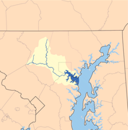
 Patapsco River Watershed | |
| Native name | Potapskut (Algonquian languages) |
| Location | |
| Country | United States |
| State | Maryland |
| Region | Baltimore metropolitan area, Patapsco Valley |
| Cities | Baltimore, Elkridge, Ellicott City |
| Physical characteristics | |
| Source | |
| • location | Marriottsville |
| • coordinates | 39°20′59″N 76°52′56″W / 39.3498272°N 76.8821987°W |
| • elevation | 260 ft (79 m) |
| Mouth | Chesapeake Bay |
• location | Baltimore |
• coordinates | 39°10′25″N 76°26′36″W / 39.1737202°N 76.4432935°W |
• elevation | 0 ft (0 m) |
| Length | 63 км |
| Basin size | 950 sq mi (2,460 km2) |
| Basin features | |
| Tributaries | |
| • left | North Branch |
| • right | South Branch |


The Patapsco River (/pəˈtæpˌskoʊ/ pə-TAP-skoh ) mainstem is a 39-mile (63 km)[1] river in central Maryland that flows into the Chesapeake Bay. The river's tidal portion forms the harbor for the city of Baltimore. With its South Branch, the Patapsco forms the northern border of Howard County, Maryland. The name "Patapsco" is derived from the Algonquian pota-psk-ut, which translates to "backwater" or "tide covered with froth".[2]
- ^ "The National Map - Advanced Viewer". apps.nationalmap.gov. Retrieved April 5, 2023.
- ^ "Ghosts of industrial heyday still haunt Baltimore's harbor, creeks". Chesapeake Bay Journal. Retrieved September 8, 2012.