Patea | |
|---|---|
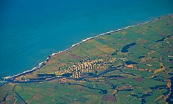
 Aerial photo of Patea | |
 | |
| Coordinates: 39°45′26″S 174°28′36″E / 39.75722°S 174.47667°E | |
| Country | New Zealand |
| Region | Taranaki Region |
| Territorial authority | South Taranaki District |
| Ward |
|
| Community | Pātea Community |
| Electorates | |
| Government | |
| • Territorial Authority | South Taranaki District Council |
| • Regional council | Taranaki Regional Council |
| Area | |
| • Total | 6.31 km2 (2.44 sq mi) |
| Population (June 2024)[2] | |
| • Total | 1,290 |
| • Density | 200/km2 (530/sq mi) |
| Postcode(s) | 4520 |

Patea (/pɑːˈtɛər/ pah-TAIR) is the third-largest town in South Taranaki District, New Zealand. It is on the western bank of the Pātea River, 61 kilometres north-west of Whanganui on State Highway 3. Hāwera is 27 km to the north-west, and Waverley 17 km to the east. The Pātea River flows through the town from the north-east and into the South Taranaki Bight.[3][4]
- ^ Cite error: The named reference
Areawas invoked but never defined (see the help page). - ^ "Aotearoa Data Explorer". Statistics New Zealand. Retrieved 26 October 2024.
- ^ Peter Dowling, ed. (2004), Reed New Zealand Atlas, Reed Books, map 44, ISBN 0-7900-0952-8
- ^ Roger Smith, GeographX (2005), The Geographic Atlas of New Zealand, Robbie Burton, map 97, ISBN 1-877333-20-4