Pawcatuck | |
|---|---|
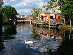
 Pawcatuck River next to the village | |
 Location in New London County, Connecticut | |
| Coordinates: 41°22′38″N 71°50′01″W / 41.37722°N 71.83361°W | |
| Country | United States |
| State | Connecticut |
| Town | Stonington |
| Area | |
| • Total | 3.42 sq mi (8.9 km2) |
| • Land | 3.41 sq mi (8.8 km2) |
| • Water | 0.012 sq mi (0.03 km2) |
| Elevation | 151 ft (46 m) |
| Population (2010) | |
| • Total | 5,624 |
| • Density | 1,644.4/sq mi (634.9/km2) |
| Time zone | UTC−5 (Eastern (EST)) |
| • Summer (DST) | UTC−4 (EDT) |
| ZIP code | 06379 |
| Area code | 860 |
| FIPS code | 09-59140 |
| GNIS feature ID | 2377850[1] |
Pawcatuck (/ˈpɔːkətʌk/ PAW-kə-tuk) is a village[2] and census-designated place (CDP) in the town of Stonington which is located in New London County, Connecticut. The population was 5,624 at the 2010 census.[3] It is located across the Pawcatuck River from Downtown Westerly, Rhode Island. The Mechanic Street Historic District of Pawcatuck is listed on the National Register of Historic Places and includes sites of shipbuilding, mills, and worker housing in a 147-acre (0.59 km2) area.[4]
- ^ U.S. Geological Survey Geographic Names Information System: Pawcatuck
- ^ Principal Communities in Connecticut, Dept. of Economic and Community Development
- ^ "Profile of General Population and Housing Characteristics: 2010 Demographic Profile Data (DP-1): Pawcatuck CDP, Connecticut". United States Census Bureau. Retrieved October 29, 2012.
- ^ "National Register Information System". National Register of Historic Places. National Park Service. March 13, 2009.