This article includes a list of general references, but it lacks sufficient corresponding inline citations. (September 2011) |
| Pea Island National Wildlife Refuge | |
|---|---|
IUCN category IV (habitat/species management area) | |
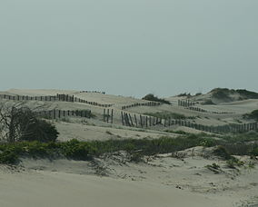
 Dunes on NC 12 in June 2007 | |
| Location | Dare County, North Carolina, United States |
| Nearest city | Nags Head, North Carolina |
| Coordinates | 35°43′N 75°30′W / 35.717°N 75.500°W |
| Area | 31,534 acres (127.61 km2) |
| Established | 1938 |
| Governing body | U.S. Fish and Wildlife Service |
| Website | Pea Island National Wildlife Refuge |
Pea Island National Wildlife Refuge is a national wildlife refuge located on North Carolina's Pea Island, a coastal barrier island and part of a chain of islands known as the Outer Banks, adjacent to Cape Hatteras National Seashore. The sanctuary is located 10 miles (16 km) south of Nags Head, North Carolina on NC 12.
The refuge's objectives are to provide nesting, resting, and wintering habitat for migratory birds, including the greater snow geese and other migratory waterfowl, shorebirds, wading birds, raptors, and neotropical migrants, as well as habitat and protection for endangered and threatened species. Objectives also include providing opportunities for public enjoyment of wildlife and wildlands resources. Public use programs focus on interpretation, environmental education, wildlife observation, wildlife photography, and fishing.

