| Peakhurst Sydney, New South Wales | |||||||||||||||
|---|---|---|---|---|---|---|---|---|---|---|---|---|---|---|---|
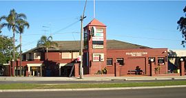
 Peakhurst Inn, Forest Road | |||||||||||||||
 | |||||||||||||||
| Population | 12,079 (2021 census)[1] | ||||||||||||||
| Established | 1840 | ||||||||||||||
| Postcode(s) | 2210 | ||||||||||||||
| Elevation | 46 m (151 ft) | ||||||||||||||
| Location | 21 km (13 mi) south-west of Sydney CBD | ||||||||||||||
| LGA(s) | Georges River Council | ||||||||||||||
| State electorate(s) | Oatley | ||||||||||||||
| Federal division(s) | Banks | ||||||||||||||
| |||||||||||||||
Peakhurst is a suburb in Southern Sydney, or the St George Area, in the state of New South Wales, Australia 21 kilometres south-west of the Sydney central business district. Peakhurst is in the local government area of the Georges River Council.
Peakhurst has a western border on Salt Pan Creek, on the Georges River. Peakhurst Heights is a separate suburb to the south, which is bordered by Boggywell Creek and Lime Kiln Bay, on the Georges River. Peakhurst Heights is sometimes still considered to be part of 'Peakhurst' by some residents of the area.
- ^ Australian Bureau of Statistics (28 June 2022). "Peakhurst (State Suburb)". 2021 Census QuickStats. Retrieved 4 October 2024.