| Pechora Sea | |
|---|---|
| Печо́рское мо́ре (Russian) | |
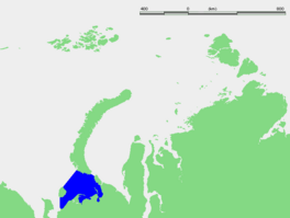
 Location of the Pechora Sea | |
| Coordinates | 69°45′N 54°00′E / 69.750°N 54.000°E |
| Type | Sea |
| Part of | Barents Sea |
| Primary inflows | Pechora River |
| River sources | Pechora River |
| Primary outflows | Arctic Ocean |
| Ocean/sea sources | Arctic Ocean |
| Catchment area | 330,000 km2 (127,000 sq mi) |
| Basin countries | Russia |
| Surface area | 81,263 km2 (31,376 sq mi) |
| Average depth | 6 m (20 ft) |
| Max. depth | 210 m (690 ft) |
| Water volume | 4,380 km3 (1,050 cu mi) |
| Salinity | 18–34.95 ‰[a] |
| Max. temperature | 8 °C (46 °F) |
| Min. temperature | −1.0 °C (30.2 °F) |
| Frozen | November to late June[1] |
| References | [3][4][2] |
The Pechora Sea (Russian: Печо́рское мо́ре, Pechorskoye More) is an Arctic sea to the north-west of European Russia, forming the south-eastern portion of the Barents Sea. It is bordered to the west by Kolguyev Island; to the east by Vaygach Island's western coasts and the Yugorsky Peninsula; and to the north by the southern end of Novaya Zemlya.
Located in the centre of the East-Atlantic flyway with conditions befitting for benthic life, the Pechora Sea supports about 600 taxa[3] and the Barents Sea's highest total biomass.[3] It is the site of the yearly migration of one of the largest salmon stocks in Northern Europe.[3] Compared to the rest of the Barents Sea, the Pechora Sea is unique for its more continental climate, lower salinity, shallowness, separation from the open sea and large input from rivers,[5][3] as well as a low level of human interference historically.[6] Its temperate characteristics are not typical of the Arctic.[5]
- ^ a b Dahle et al. 1998, p. 184.
- ^ a b c Dahle et al. 1998, p. 185.
- ^ a b c d e Convention on Biological Diversity 2015.
- ^ Britannica 1998.
- ^ a b Polyak, Stanovoy & Lubinski 2003, p. 1.
- ^ Gebruk et al. 2021, p. 57.
Cite error: There are <ref group=lower-alpha> tags or {{efn}} templates on this page, but the references will not show without a {{reflist|group=lower-alpha}} template or {{notelist}} template (see the help page).


