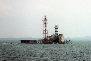
 Pedra Branca and Horsburgh Lighthouse | |
 Location of Pedra Branca | |
| Geography | |
|---|---|
| Coordinates | 01°19′49″N 104°24′21″E / 1.33028°N 104.40583°E |
| Administration | |
| Region | East Region |
| CDC | South East CDC |
| Town council | East Coast–Fengshan Town Council |
| Constituency | East Coast GRC |
Pedra Branca (Portuguese pronunciation: [ˈpɛðɾɐ ˈβɾɐ̃kɐ]), also known as Batu Putih, is an outlying island and the easternmost point of Singapore.[1] The name of the island, which is Portuguese for "white rock", refers to whitish guano deposited on the rock. The island consists of a small outcrop of granite rocks with an area of about 8,560 square metres (92,100 sq ft) at low tide. During the low water spring tide it measures, at its longest, 137 metres (449 ft) and has an average width of 60 metres (200 ft). Pedra Branca is situated at 1°19′48″N 104°24′27″E / 1.33000°N 104.40750°E, where the Singapore Strait meets the South China Sea.
There are two maritime features near Pedra Branca. Middle Rocks, under the sovereignty of Malaysia, consists of two clusters of small rocks about 250 metres (820 ft) apart situated 0.6 nautical miles (1.1 km; 0.7 mi) south of Pedra Branca. South Ledge, which is 2.2 nautical miles (4.1 km; 2.5 mi) to the south-south-west of Pedra Branca, is a rock formation visible only at low-tide.
Pedra Branca was known to sailors for centuries. It was originally within the territory of the Johor Sultanate, which was founded in 1528, and remained under the new Sultanate of Johor while under the British sphere of influence following the signing of the Anglo-Dutch Treaty of 1824 between the United Kingdom and the Netherlands. Between 1850 and 1851, the British built Horsburgh Lighthouse on the island without seeking the consent of the Johor authorities or informing them of the decision. From that time, the Straits Settlements administered the island; Singapore then assumed responsibility in 1946 after the dissolution of the Straits Settlements. On 21 September 1953, the Acting State Secretary of Johor, responding to a query from the Colonial Secretary of Singapore about the status of the island, stated that "the Johore Government does not claim ownership of Pedra Branca".
On 21 December 1979, Malaysia published a map that showed the island to be within its territorial waters. This ignited a 29-year territorial dispute which, together with the issue of sovereignty over the nearby maritime features of Middle Rocks and South Ledge, the disputants presented to the International Court of Justice (ICJ) for resolution. On 23 May 2008, the ICJ ruled that Pedra Branca was under Singapore's sovereignty. At this point, the ICJ also noted Singapore's plans to conduct reclamation at Pedra Branca.[2] Although the island had originally been under the sovereignty of the Johor Sultanate, the United Kingdom and Singapore had carried out various acts of sovereignty in respect of the island. The failure of Malaysia and its predecessors to respond to these acts, and other actions that demonstrated their acknowledgment of Singapore's sovereignty over the island, meant that Singapore had gained sovereignty over Pedra Branca. On the other hand, Middle Rocks remain part of Malaysian territory as Singapore had not manifested any acts of sovereignty in respect to it. The Court did not rule definitively on the remaining outcrop, South Ledge, declaring that it belonged to the state in the territorial waters of which it is located. Malaysia and Singapore have established the Joint Technical Committee to delimit the maritime boundary in the area around Pedra Branca and Middle Rocks, and to determine the ownership of South Ledge.
On 1 February 2019, Pedra Branca was added to East Coast GRC for the Parliament of Singapore.
- ^ For the history, historical cartography, and toponymy of Pedra Branca, cf. Ong, Brenda Man Qing, and Francesco Perono Cacciafoco. (2022). Pedra Branca off Singapore: A Historical Cartographic Analysis of a Post-Colonial Territorially Disputed Island. Histories, 2, 1: 47-67, Paper Archived 16 May 2022 at the Wayback Machine, DOI: https://doi.org/10.3390/histories2010005.
- ^ "Development Works at Pedra Branca to Enhance Maritime Safety and Security". www.mnd.gov.sg. Archived from the original on 12 July 2021. Retrieved 12 July 2021.