Pelican Narrows
ᐅᐹᐏᑯᐢᒋᑲᓂᕽ opâwikoscikanihk | |
|---|---|
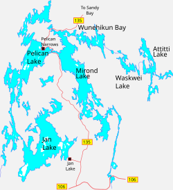
 Surrounding lakes | |
Location of Pelican Narrows in Saskatchewan | |
| Coordinates: 55°11′18″N 102°56′03″W / 55.18833°N 102.93417°W[2] | |
| Country | Canada |
| Province | Saskatchewan |
| District | Northern Saskatchewan Administration District |
| Census Division | 18 |
| Post office established | 1949 |
| Area (2021)[3] | |
| • Northern village | 2.40 km2 (0.93 sq mi) |
| Elevation (airport)[4] | 385 m (1,264 ft) |
| Population (2021)[3] | |
| • Northern village | 123 |
| • Northern village density | 51.3/km2 (133/sq mi) |
| Time zone | UTC−06:00 (CST) |
| • Summer (DST) | UTC−05:00 (CDT) |
| Postal code | S0P 0E0 |
| [5][6] | |
Pelican Narrows (Woods Cree: ᐅᐹᐏᑯᐢᒋᑲᓂᕽ, romanized: opâwikoscikanihk, lit. 'The Narrows of Fear') is a northern village in the boreal forest of central Saskatchewan, Canada. Its location is on Pelican Lake about 120 km (75 mi) northwest of Creighton by the Hanson Lake Road and Highway 135.
The community is northwest of the narrows that join Mirond and Pelican Lakes, which lie between the Sturgeon-Weir and Churchill River systems. Pelican Narrows is the administrative headquarters for the Peter Ballantyne Cree Nation, a member of the Prince Albert Grand Council, and the majority of the townsite is reserve land. The community consists of the Northern Village of Pelican Narrows and Pelican Narrows 184B and Pelican Narrows 206 Indian Reserve. Together they formed a population centre of about 2,133 people in 2021.[7]
- ^ "Search for Municipal Information". Government of Saskatchewan. Retrieved April 7, 2014.
- ^ "Pelican Narrows". Geographical Names Data Base. Natural Resources Canada.
- ^ a b Cite error: The named reference
censusPNNVwas invoked but never defined (see the help page). - ^ Cite error: The named reference
CFSwas invoked but never defined (see the help page). - ^ National Archives, Archivia Net. "Post Offices and Postmasters". Archived from the original on December 25, 2018. Retrieved March 17, 2014.
- ^ Government of Saskatchewan, MRD Home. "Municipal Directory System". Retrieved March 17, 2014.
- ^ "Census Profile, 2021 Census of Population - Profile table - Pelican Narrows: Saskatchewan [Population centre]". February 1, 2023. Retrieved March 17, 2024.

