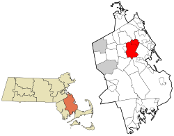
Pembroke, Massachusetts | |
|---|---|
 Pembroke Town Hall | |
 Location in Plymouth County in Massachusetts | |
| Coordinates: 42°4′N 70°49′W / 42.067°N 70.817°W | |
| Country | United States |
| State | Massachusetts |
| County | Plymouth |
| Settled | 1650 |
| Incorporated | 1712 |
| Named for | Pembroke, Wales |
| Government | |
| • Type | Open town meeting |
| Area | |
• Total | 23.5 sq mi (60.8 km2) |
| • Land | 21.8 sq mi (56.6 km2) |
| • Water | 1.6 sq mi (4.2 km2) |
| Elevation | 70 ft (21 m) |
| Population (2020) | |
• Total | 18,361 |
| • Density | 842.2/sq mi (324.4/km2) |
| Time zone | UTC−5 (Eastern) |
| • Summer (DST) | UTC−4 (Eastern) |
| ZIP Codes | 02359, 02327, 02358 |
| Area code | 339/781 |
| FIPS code | 25-52630 |
| GNIS feature ID | 0618348 |
| Website | www.townofpembrokemass.org |
Pembroke is an historic town in Plymouth County, Massachusetts, United States. Pembroke is a South Shore suburb of the Boston metropolitan area. The town is located approximately halfway between Boston and Cape Cod. The town is considered rural in character, with pockets of suburban neighborhoods. The population was 18,361 at the 2020 census, with a median household income of $119,827.[1]
Neighborhoods include Bryantville (along the Hanson town line), North Pembroke and East Pembroke.
- ^ "Census - Geography Profile: Pembroke town, Plymouth County, Massachusetts". United States Census Bureau. Retrieved November 6, 2021.

