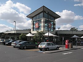
| Pemulwuy Greater Western Sydney, New South Wales | |||||||||||||||
|---|---|---|---|---|---|---|---|---|---|---|---|---|---|---|---|
 Pemulwuy Marketplace | |||||||||||||||
 | |||||||||||||||
| Population | 5,532 (2021 census)[1] | ||||||||||||||
| Postcode(s) | 2145 | ||||||||||||||
| Elevation | 69 m (226 ft) | ||||||||||||||
| Location | 30 km (19 mi) west of Sydney CBD | ||||||||||||||
| LGA(s) | Cumberland Council | ||||||||||||||
| State electorate(s) | Prospect | ||||||||||||||
| Federal division(s) | McMahon | ||||||||||||||
| |||||||||||||||
Pemulwuy is a suburb in Greater Western Sydney, in the state of New South Wales, Australia. Pemulwuy is located 30 kilometres west of the Sydney central business district in the local government area of the Cumberland Council. Pemulwuy is home to the highest point between the Blue Mountains and Sydney, the summit of Prospect Hill.
The quarrying of blue metal, basalt and dolerite was abundant in the area in the past two centuries.[2] Pemulwuy, formerly part of Prospect, is a relatively new suburb, with development beginning in 2004 on the site of a former Boral quarry and CSIRO sites.[3][4]
- ^ Australian Bureau of Statistics (28 June 2022). "Pemulwuy (State Suburb)". 2021 Census QuickStats. Retrieved 4 October 2024.
- ^ England, B.M., Minerals of the Prospect Intrusion, New South Wales, Australia, in The Mineralogical Record 1994
- ^ Cite error: The named reference
Holroydwas invoked but never defined (see the help page). - ^ "Pemulwuy". Geographical Names Register (GNR) of NSW. Geographical Names Board of New South Wales. Retrieved 7 August 2013.