| Penong South Australia | |||||||||||||||
|---|---|---|---|---|---|---|---|---|---|---|---|---|---|---|---|
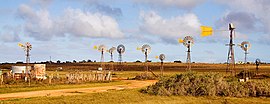
 Windmills adjacent to Penong: each is privately owned and supplies houses and farms with water from the Anjutabie Basin. | |||||||||||||||
| Coordinates | 31°55′47″S 133°00′34″E / 31.929848°S 133.00955°E[1] | ||||||||||||||
| Population | 280 (SAL 2021)[2] | ||||||||||||||
| Established | 28 April 1892 (town) 8 February 2001 (locality)[3][4] | ||||||||||||||
| Postcode(s) | 5690[5] | ||||||||||||||
| Time zone | ACST (UTC+9:30) | ||||||||||||||
| • Summer (DST) | ACST (UTC+10:30) | ||||||||||||||
| Location |
| ||||||||||||||
| LGA(s) | Pastoral Unincorporated Area[1] | ||||||||||||||
| Region | Eyre Western[6] | ||||||||||||||
| County | Kintore[1] | ||||||||||||||
| State electorate(s) | Flinders[7] | ||||||||||||||
| Federal division(s) | Grey[8] | ||||||||||||||
| |||||||||||||||
| |||||||||||||||
| Footnotes | Adjoining localities[1] | ||||||||||||||
Penong (/pəˈnɒŋ/ p(ə)-NONG) is a town and locality on the Nullarbor Plain, in the far west of the state of South Australia located about 616 kilometres (383 mi) north-west of the state capital of Adelaide.[5] With no settlements between it and Border Village on the border with Western Australia, 400 km (250 mi) away on the Eyre Highway, it is a popular rest-stop for travellers.
The 2016 Australian census recorded that the localities of Penong and the small farming community of Bookabie (including the Scotdesco Aboriginal community), 35 km (22 mi) to Penong's west, had a population of 289 people.
Penong is the closest town to the Chadinga Conservation Park. To its south is Cactus Beach, a popular surfing beach on the western side of Point Sinclair; Port Le Hunte – also known as Port Irvine[10] – is on the sheltered eastern side.[11] The Lake MacDonnell gypsum field – the largest in the Southern Hemisphere[12] – is near the coast 15 km (9 mi) to the south. The major port of Cape Thevenard, collocated with Ceduna, is 75 km (45 mi) to the south-east.

- ^ a b c d "Search results for 'Penong, LOCB' with the following datasets selected – 'Suburbs and localities', 'Counties', 'Government Towns', 'Hundreds', 'Local Government Areas', 'SA Government Regions' and 'Gazetteer'". Location SA Map Viewer. South Australian Government. Retrieved 28 January 2019.
- ^ Australian Bureau of Statistics (28 June 2022). "Penong (suburb and locality)". Australian Census 2021 QuickStats. Retrieved 28 June 2022.
- ^ Kingston, C.C. (28 April 1892). "Untitled proclamation re Town of Penong" (PDF). The South Australian Government Gazette. Government of South Australia. pp. 939–940. Retrieved 28 January 2019.
- ^ Lawson, Robert (8 February 2001). "Geographical Names Act 1991 Notice to assign names and boundaries to places" (PDF). The South Australian Government Gazette. Government of South Australia. p. 516. Retrieved 27 January 2019.
...assign the boundaries Lyndhurst, Leigh Creek, Copley, Parachilna, Marla, Nepabunna, Oodnadatta, Andamooka, Penong, Coorabie and Fowlers Bay...
- ^ a b c "Postcode for Penong, South Australia". postcodes-australia.com. Retrieved 21 October 2019.
- ^ "Eyre and Western South Australian Government Region" (PDF). Government of South Australia. Retrieved 29 January 2016.
- ^ "District of Flinder Background Profile". Electoral Commission SA. Retrieved 1 June 2019.
- ^ "Federal electoral division of Grey" (PDF). Australian Electoral Commission. Retrieved 1 June 2019.
- ^ a b c "Climate Statistics for Fowlers Bay, South Australia (nearest weather station)". Retrieved 21 October 2019.
- ^ "Placename Details: Port Irvine". Property Location Browser. Government of South Australia. 1 March 2010. SA0032330. Archived from the original on 12 October 2016. Retrieved 25 December 2016.
- ^ "Placename Details: Port Le Hunte". Property Location Browser. Government of South Australia. 1 March 2010. SA0038991. Archived from the original on 12 October 2016. Retrieved 24 December 2016.
- ^ "Lake Macdonnell". MiningLink. Retrieved 12 August 2015.
