

Pensacola Bay is a bay located in the northwestern part of Florida, United States, known as the Florida Panhandle.
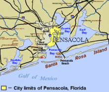
The bay, an inlet of the Gulf of Mexico, is located in Escambia County and Santa Rosa County, adjacent to the city of Pensacola, Florida, and is about 13 miles (21 km) long and 2.5 miles (4 km) wide. The Pensacola Bay estuarine system, which also includes Escambia Bay, Blackwater Bay, East Bay, Santa Rosa Sound, and the Escambia, Blackwater, Yellow, and East Bay rivers, is 144 square miles, and it is the fourth largest estuarine system in Florida.[1]
Pensacola Bay is formed and protected by Fairpoint Peninsula and the barrier island of Santa Rosa. The Pensacola Bay Bridge crosses the bay, connecting Pensacola to Gulf Breeze on the western end of the peninsula. The Gulf Islands National Seashore includes Santa Rosa Island, and encloses part of the bay. The Gulf Intracoastal Waterway runs through a section of the bay. Pensacola Bay is bordered by Escambia Bay and East Bay to the north, and Santa Rosa Sound to the east. Pensacola Pass connects the Bay to the Gulf of Mexico.