| Pere Marquette River | |
|---|---|
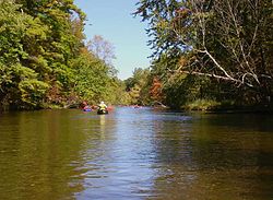
 Tourists canoeing on the Pere Marquette River in the Manistee National Forest | |
 | |
| Location | |
| Country | United States |
| State | Michigan |
| Counties | Lake, Mason, Newaygo, Oceana |
| Cities | Ludington, Scottville |
| Physical characteristics | |
| Source | |
| • location | Lake County, Michigan, United States |
| • coordinates | 43°51′22″N 85°50′30″W / 43.85611°N 85.84167°W |
| Mouth | Lake Michigan |
• location | Ludington, Michigan, United States |
• coordinates | 43°57′06″N 86°27′37″W / 43.95167°N 86.46028°W |
| Length | 64 mi (103 km) |
| Basin size | 740 sq mi (1,900 km2) |
| Basin features | |
| Tributaries | |
| • left | Little South Branch, Big South Branch |
| • right | Middle Branch, Baldwin River |
| Type | Scenic |
| Designated | November 10, 1978 |
The Pere Marquette River is a river in Michigan in the United States. The main stream of this river is 63.9 miles (102.8 km) long,[1] running from Lake County south of Baldwin into the Pere Marquette Lake, and from there into Lake Michigan.[2]
This river is named after the French Roman Catholic missionary Jacques Marquette, who explored the Great Lakes and Mississippi River areas during the mid-17th century. He died in the vicinity of the river in spring 1675 on his way from Chicago to the French fort at Mackinaw.
- ^ U.S. Geological Survey. National Hydrography Dataset high-resolution flowline data. The National Map, accessed November 21, 2011
- ^ "Pere Marquette River". Geographic Names Information System. United States Geological Survey, United States Department of the Interior.