| Peshtigo River | |
|---|---|
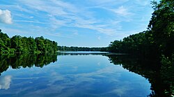
 The Peshtigo River in Stephenson | |
 | |
| Physical characteristics | |
| Source | |
| • location | Argonne, Wisconsin |
| • coordinates | 45°40′10″N 88°48′48″W / 45.66944°N 88.81333°W[1] |
| Mouth | |
• location | Green Bay (Lake Michigan) near Peshtigo, Wisconsin |
• coordinates | 44°58′25″N 87°39′20″W / 44.97361°N 87.65556°W |
• elevation | 577 ft (176 m) |
| Length | 136 mi (219 km) |
The Peshtigo River (/ˈpɛʃtɪɡoʊ/ PESH-ti-go) is a 136-mile-long (219 km)[2] tributary of Green Bay in the U.S. state of Wisconsin. The Peshtigo Fire happened in the river's vicinity, and some survivors used the river for refuge from the flames. A section of whitewater on the river called the Roaring Rapids is well known in the region. Further downstream there are two dams known as Caldron Falls Dam and High Falls Dam before collecting the Thunder River.
- ^ "Peshtigo River". Geographic Names Information System. United States Geological Survey, United States Department of the Interior.
- ^ U.S. Geological Survey. National Hydrography Dataset high-resolution flowline data. The National Map, accessed December 19, 2011