| Petawawa River | |
|---|---|
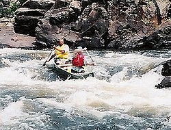
 The dangerous Crooked Chute in Algonquin Provincial Park | |
| Etymology | From the Algonquian for "where one hears a noise like this" |
| Location | |
| Country | Canada |
| Province | Ontario |
| Regions | |
| County/District | |
| Physical characteristics | |
| Source | Ralph Bice Lake |
| • location | Geographic township of Butt, Unorganized South Part, Nipissing District |
| • coordinates | 45°40′49″N 78°57′02″W / 45.68028°N 78.95056°W |
| • elevation | 443 m (1,453 ft) |
| Mouth | Ottawa River |
• location | Petawawa, Renfrew County |
• coordinates | 45°54′38″N 77°15′31″W / 45.91056°N 77.25861°W |
• elevation | 110 m (360 ft) |
| Length | 187 km (116 mi) |
| Basin size | 4,200 km2 (1,600 sq mi) |
| Discharge | |
| • average | 45 m3/s (1,600 cu ft/s) |
| Basin features | |
| Progression | Ottawa River→ St. Lawrence River→ Gulf of St. Lawrence |
| River system | Ottawa River drainage basin |
| Tributaries | |
| • left | North River, Nipissing River, Tim River |
| • right | Barron River, Crow River, Little Madawaska River |
The Petawawa River is a river in the Saint Lawrence River drainage basin in Nipissing District and Renfrew County in eastern and northeastern Ontario, Canada.[1][2] The river flows from Algonquin Provincial Park to the Ottawa River at the town of Petawawa, and is only one of two major tributaries of the Ottawa River to flow completely freely (the other being the Dumoine River).[3] The river's name comes from the Algonquian for "where one hears a noise like this", which refers to its many rapids.
- ^ "Petawawa River". Geographical Names Data Base. Natural Resources Canada. Retrieved 2011-07-24.
- ^ "Petawawa River". Atlas of Canada. Natural Resources Canada. 2010-02-04. Retrieved 2011-07-24. Shows the river course.
- ^ Kelly Egan (September 26, 2012). "Muddy waters surround Petawawa dam project". Ottawa Citizen.
