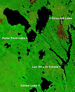
| Peter Pond Lake | |
|---|---|
 | |
| Location | Northern Saskatchewan Administration District |
| Coordinates | 55°54′58″N 108°44′03″W / 55.9161°N 108.7341°W |
| Type | Glacial lake |
| Primary inflows | Dillon River La Loche River |
| Primary outflows | Churchill Lake |
| Catchment area | 9,713 km2 (3,750 sq mi) |
| Basin countries | Canada |
| Surface area | 778 km2 (300 sq mi) |
| Average depth | 13.7 m (45 ft) |
| Max. depth | 24 m (79 ft) |
| Water volume | 10.6 km3 (2.5 cu mi) |
| Residence time | 6.5 years |
| Shore length1 | 124 km (77 mi) |
| Surface elevation | 421 m (1,381 ft) |
| Islands |
|
| Settlements | |
| References | [2] |
| 1 Shore length is not a well-defined measure. | |
Peter Pond Lake[3] is a glacial lake in the north-western part of the Canadian province of Saskatchewan. It is located in the boreal forest and Canadian Shield within the Churchill River drainage basin.[4][5]
- ^ "NASA Visible Earth (BURN SCARS IN SASKATCHEWAN, CANADA) Note: Dark to light rust coloured areas are burn scars from forest fires". August 24, 2002. Retrieved September 14, 2014.
- ^ "World Lake Database (Peter Pond Lake)". Archived from the original on March 18, 2012. Retrieved October 12, 2012.
- ^ "Peter Pond Lake". Canadian Geographical Names Database. Government of Canada. Retrieved January 12, 2023.
- ^ "Peter Pond Lake". International Association for Great Lakes Research. Retrieved January 14, 2023.
- ^ "Peter Pond Lake Fishing Map". GPS Nautical Charts. Bist LLC. Retrieved January 14, 2023.

