Peterborough County | |
|---|---|
| County of Peterborough | |
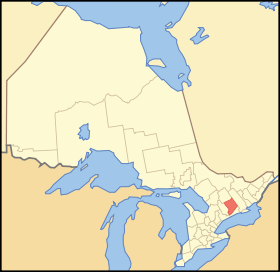
 Location of Peterborough County | |
| Coordinates: 44°30′N 78°10′W / 44.500°N 78.167°W | |
| Country | |
| Province | |
| Region | Central Ontario |
| Founded | 1838 (as District of Colborne) |
| County seat | Peterborough |
| Municipalities | |
| Area | |
| • Land | 3,769.29 km2 (1,455.33 sq mi) |
| Population (2016)[2] | |
| • Total | 55,800 |
| • Density | 14.8/km2 (38/sq mi) |
| Time zone | UTC-5 (EST) |
| • Summer (DST) | UTC-4 (EDT) |
| Website | www.ptbocounty.ca |
Peterborough County is located in Southern Ontario, Canada. The county seat is The City of Peterborough, which is independent of the county.
The southern section of the county is mix of agriculture, urban and lakefront properties. The northern section of the county is mostly sparsely populated wilderness with numerous rivers and lakes, mostly within Kawartha Highlands Provincial Park.
The County contains the Lang Pioneer Village, and the Kawarthas are a major tourist region.
- ^ "Peterborough County census profile". 2011 Census of Population. Statistics Canada. Archived from the original on 2017-12-01. Retrieved 2012-03-22.
- ^ Cite error: The named reference
cp2016was invoked but never defined (see the help page).