| Petoskey State Park | |
|---|---|
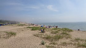
 Beachfront along Lake Michigan | |
| Location | Lower Peninsula, Emmet County, Michigan, United States |
| Nearest city | Petoskey, Michigan |
| Coordinates | 45°24′05″N 84°54′30″W / 45.40139°N 84.90833°W[2] |
| Area | 303 acres (123 ha) |
| Elevation | 630 feet (190 m)[2] |
| Designation | Michigan State Park |
| Established | 1961[3] |
| Administrator | Michigan Department of Natural Resources |
| Website | Petoskey State Park |
Petoskey State Park is a public recreation area covering 303 acres (123 ha) on Lake Michigan in Bear Creek Township, Emmet County, Michigan. The state park is located three miles (4.8 km) northeast of the city of Petoskey on Little Traverse Bay. It is surrounded by heavily vegetated sand dunes that are excellent examples of parabolic dunes.[4] Michigan's state stone, the Petoskey stone, can be found on the park beach.[5]
- ^ "Petoskey State Park". IUCN. Retrieved April 5, 2020.
- ^ a b "Petoskey State Park". Geographic Names Information System. United States Geological Survey, United States Department of the Interior.
- ^ Cite error: The named reference
mdnr3was invoked but never defined (see the help page). - ^ Cite error: The named reference
duneswas invoked but never defined (see the help page). - ^ Cite error: The named reference
mdnrwas invoked but never defined (see the help page).

