Petten | |
|---|---|
Village | |
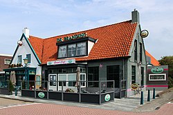
 Pub in Petten | |
| Coordinates: 52°46′N 4°40′E / 52.767°N 4.667°E | |
| Country | Netherlands |
| Province | North Holland |
| Municipality | Schagen |
| Area | |
| • Total | 7.17 km2 (2.77 sq mi) |
| Elevation | 0.4 m (1.3 ft) |
| Population (2021)[1] | |
| • Total | 1,640 |
| • Density | 230/km2 (590/sq mi) |
| Time zone | UTC+1 (CET) |
| • Summer (DST) | UTC+2 (CEST) |
| Postal code | 1755[1] |
| Dialing code | 0226 |
Petten is a village in the Dutch province of North Holland. It is a part of the municipality of Schagen, and lies about 15 km northwest of Alkmaar, on the North Sea. The population is ca. 1900.
Petten's economy is based on agriculture (bulb cultivation), and tourism. A particular type sand can be found on the beach of Petten, of sanded quartz with granite. Since 1997 a plan has been developed for a marina with 600 places; called Marina Petten.
Somewhat to the south of Petten, the dunes have been eroded, as a result of which a dike had to be built, the Hondsbossche and Pettemer zeewering.
- ^ a b c "Kerncijfers wijken en buurten 2021". Central Bureau of Statistics. Retrieved 1 May 2022.
- ^ "Postcodetool for 1755KK". Actueel Hoogtebestand Nederland (in Dutch). Het Waterschapshuis. Retrieved 1 May 2022.


