| Phoenix Islands Protected Area | |
|---|---|
| PIPA | |
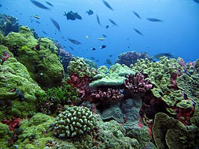
 PIPA represents one of Earth’s last intact oceanic coral archipelago ecosystems with reefs being what a reef might have looked like one thousand years ago. | |
 Phoenix Islands Protected Area boundary outlined | |
| Location | Phoenix Islands |
| Area | 408,250 km2 |
| Established | January 2008 |
| Governing body | Republic of Kiribati |
| www | |
| Type | Natural |
| Criteria | vii, ix |
| Designated | 2010 (34th session) |
| Reference no. | 1325 |
| Region | Asia-Pacific |

The Phoenix Islands Protected Area (PIPA) is located in the Republic of Kiribati, an ocean nation in the central Pacific approximately midway between Australia and Hawaii. PIPA constitutes 11.34% of Kiribati's exclusive economic zone (EEZ), and with a size of 408,250 km2 (157,630 sq mi), it is one of the largest marine protected areas (MPA) and one of the largest protected areas of any type (land or sea) on Earth.[1] The PIPA was also designated as the world's largest and deepest UNESCO World Heritage Site in 2010.[2]
The PIPA conserves one of the world's largest intact oceanic coral archipelago ecosystems, includes 14 known underwater seamounts (presumed to be extinct volcanoes) and other deep-sea habitats. The area contains approximately 800 known species of fauna, including about 200 coral species, 500 fish species, 18 marine mammals and 44 bird species.[3][4][1] In total it is equivalent to the size of the state of California in the US, though the total land area is only 25 km2 (9.7 sq mi).[5] To the north of the PIPA is the U.S. administered Pacific Remote Islands Marine National Monument that is currently the world's largest designated MPA.
- ^ a b Rotjan, Randi (2014). Establishment, management, and maintenance of the Phoenix Islands Protected Area. In: Advances in Marine Biology. Elsevier, Oxford Press. ISBN 978-0-12-800214-8.
- ^ "Phoenix Islands Protected Area". conservation International. 2020. Retrieved 29 March 2021.
- ^ "Phoenix Islands Protected Area". UNESCO. 2020. Retrieved 29 March 2021.
- ^ Pierce, R.J., and D. Brown (16 April 2008). "Phoenix Islands Restoration Project" (PDF). NZAID – PIPA. Retrieved 29 March 2021.
{{cite web}}: CS1 maint: multiple names: authors list (link) - ^ Christopher Pala (2 October 2008). "Ocean wilderness is size of California". Cosmos magazine. Cosmos Media Ltd. Archived from the original on 10 February 2014. Retrieved 2013-06-07.
The Phoenix Islands Protected Area will be the size of California, the first that protects tuna and other ocean-going fish and the first to get funding using market-based mechanisms.