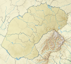
Phuthaditjhaba | |
|---|---|
 Mandela Park shopping centre | |
| Coordinates: 28°32′00″S 28°49′00″E / 28.53333°S 28.81667°E | |
| Country | South Africa |
| Province | Free State |
| District | Thabo Mofutsanyana |
| Municipality | Maluti a Phofung |
| Established | 1974 |
| • Councillor | (ANC) |
| Area | |
| • Total | 23.83 km2 (9.20 sq mi) |
| Elevation | 1,646 m (5,400 ft) |
| Population (2011)[1] | |
| • Total | 54,661 |
| • Density | 2,300/km2 (5,900/sq mi) |
| Racial makeup (2011) | |
| • Black African | 99.0% |
| • Coloured | 0.2% |
| • Indian/Asian | 0.5% |
| • White | 0.1% |
| • Other | 0.2% |
| First languages (2011) | |
| • Sotho | 88.8% |
| • Zulu | 4.4% |
| • English | 2.0% |
| • Sign language | 1.5% |
| • Other | 3.3% |
| Time zone | UTC+2 (SAST) |
| Postal code (street) | 9866 |
| PO box | 9869 |
| Area code | 058 |
Phuthaditjhaba (previously Witsieshoek), is a town in the Free State province of South Africa. It is located in a section of the Drakensberg mountains (Maloti in the Sesotho language). It borders the province of KwaZulu-Natal to the south east and the independent country of Lesotho to the south west. The town was capital of the bantustan, or homeland, of QwaQwa. When apartheid ended, the town became part of the Free State province.
- ^ a b c d "Main Place Phuthaditjhaba". Census 2011.

