You can help expand this article with text translated from the corresponding article in Spanish. (March 2009) Click [show] for important translation instructions.
|
Piedras Negras, Coahuila | |
|---|---|
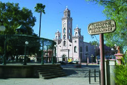
 Church of Our Lady of Guadalupe | |
| Nickname: The Safe Border! | |
| Coordinates: 28°42′00″N 100°31′23″W / 28.70000°N 100.52306°W | |
| Country | Mexico |
| State | Coahuila |
| Municipality | Piedras Negras |
| Established | June 15, 1850 |
| Government | |
| • Mayor | Norma Treviño González (PRI) |
| Area | |
| • City | 914.2 km2 (353.0 sq mi) |
| Elevation | 223 m (732 ft) |
| Population (2020) | |
| • City | 173,959[1] |
| • Metro | 245,155[1] |
| Demonym | Nigropetense |
| Time zone | UTC-6 (Central (US Central)) |
| • Summer (DST) | UTC-5 (Central) |
| Postal code | 26000 |
| Area code | 878 |
| Airport | Piedras Negras Int. Airport |
| Website | www |
Piedras Negras (Spanish pronunciation: [ˈpjeðɾas ˈneɣɾas] lit. 'Black Rocks') is a city and seat of the surrounding municipality of the same name in the Mexican state of Coahuila. It stands at the northeastern edge of Coahuila on the Mexico–United States border, across the Rio Grande from Eagle Pass in the U.S. state of Texas. In the 2015 census the city had a population of 163,595 inhabitants,[1] while the metropolitan area had a population of 245,155 inhabitants.[1] The Piedras Negras and the Eagle Pass areas are connected by the Eagle Pass–Piedras Negras International Bridge, Camino Real International Bridge, and the Union Pacific International Railroad Bridge.
In Spanish, Piedras Negras translates to 'black stones' – a reference to coal deposits in the area. Across the river, coal was formerly mined on the U.S. side at Dolchburg, near Eagle Pass. This mine closed around 1905, after a fire. Mexico currently operates two large coal-fired power stations named "José López Portillo" and "Carbón 2" located 30 miles (48 km) south of Piedras Negras. These two coal-fired power plants are currently operated by Comisión Federal de Electricidad, the state-owned Mexican electric utility.
- ^ a b c d "Número de habitantes. Coahuila de Zaragoza". www.cuentame.inegi.org.mx.


