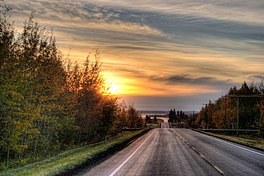
| Pigeon Lake | |
|---|---|
 Looking west over Pigeon Lake at sunset | |
| Location | Leduc County and County of Wetaskiwin No. 10, Alberta |
| Coordinates | 53°01′49″N 114°03′48″W / 53.03028°N 114.06333°W |
| Primary outflows | Pigeon Lake Creek |
| Catchment area | 187 km2 (72 sq mi) |
| Basin countries | Canada |
| Max. length | 13.1 km (8.1 mi) |
| Max. width | 14.7 km (9.1 mi) |
| Surface area | 96.7 km2 (37.3 sq mi) |
| Average depth | 6.2 m (20 ft) |
| Max. depth | 9.1 m (30 ft) |
| Surface elevation | 852 m (2,795 ft) |
| Settlements | Argentia Beach, Crystal Springs, Fisher Home, Golden Days, Grandview, Itaska Beach, Ma-Me-O Beach, Mission Beach, Mulhurst Bay, Norris Beach, Pigeon Lake 138A, Poplar Bay, Silver Beach, Sundance Beach, Village at Pigeon Lake |
| References | Pigeon Lake |
Pigeon Lake is a lake in central Alberta, Canada that straddles the boundary between Leduc County and the County of Wetaskiwin No. 10. It is located close to Edmonton, Leduc and Wetaskiwin. Communities along the lakeshore include Pigeon Lake Indian Reserve 138A, ten summer villages (Argentia Beach, Crystal Springs, Golden Days, Grandview, Itaska Beach, Ma-Me-O Beach, Norris Beach, Poplar Bay, Silver Beach and Sundance Beach), and four unincorporated communities (Fisher Home, Mission Beach, Mulhurst Bay and Village at Pigeon Lake).
The lake has a total area of 96.7 km2 (37.3 sq mi) and a maximum depth of 9.1 m (30 ft). It has a catchment area of 187 km2 (72 sq mi),[1] and is an early tributary of the Battle River, to which it is connected through the Pigeon Lake Creek.
Pigeon Lake was previously called "Woodpecker Lake". The name was changed to Pigeon Lake in 1858. In 1896, Pigeon Lake Indian Reserve was established on the southeast shore. Later, the summer village of Ma-Me-O Beach was developed at the south end of the lake on land obtained from the Indian reserve in 1924. Ma-Me-O (omîmîw) is a Cree word meaning "pigeon".
- ^ "Pigeon Lake". in Atlas of Alberta Lakes. University of Alberta Press. 1990. Retrieved 24 November 2019.
