Pike County | |
|---|---|
 Pike County Courthouse in Petersburg | |
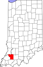
 Location within the U.S. state of Indiana | |
 Indiana's location within the U.S. | |
| Coordinates: 38°24′N 87°14′W / 38.4°N 87.23°W | |
| Country | |
| State | |
| Founded | December 21, 1816 |
| Named for | Zebulon Pike |
| Seat | Petersburg |
| Largest city | Petersburg |
| Area | |
| • Total | 341.09 sq mi (883.4 km2) |
| • Land | 334.24 sq mi (865.7 km2) |
| • Water | 6.86 sq mi (17.8 km2) 2.01% |
| Population (2020) | |
| • Total | 12,250 |
| • Density | 36/sq mi (14/km2) |
| Time zone | UTC−5 (Eastern) |
| • Summer (DST) | UTC−4 (EDT) |
| Congressional district | 8th |
| Website | www |
| |
Pike County is a county in the southwest portion of the U.S. state of Indiana. As of the 2020 United States census, the population was 12,250.[1] The county seat is Petersburg.[2] It contains the geographic point representing median center of US population in 2010.[3]
Pike County is part of the Jasper Micropolitan Statistical Area.
- ^ "Quickfacts: Pike County, Indiana". United States Census Bureau. Retrieved June 6, 2023.
- ^ "Find a County". National Association of Counties. Retrieved June 7, 2011.
- ^ 2010 Census/Documentation