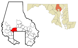
Pikesville, Maryland | |
|---|---|
 The entrance to Pikesville High School, located at the intersection of Labyrinth Road and Smith Avenue. | |
 Location of Pikesville, Maryland | |
| Coordinates: 39°22′45″N 76°42′18″W / 39.37917°N 76.70500°W | |
| Country | |
| State | |
| County | |
| Area | |
| • Total | 12.38 sq mi (32.06 km2) |
| • Land | 12.35 sq mi (31.99 km2) |
| • Water | 0.03 sq mi (0.07 km2) |
| Elevation | 509 ft (155 m) |
| Population (2020) | |
| • Total | 34,168 |
| • Density | 2,766.64/sq mi (1,068.21/km2) |
| Demonym | Pikesvillian |
| Time zone | UTC−5 (Eastern (EST)) |
| • Summer (DST) | UTC−4 (EDT) |
| ZIP codes | 21208, 21282,21209,21215 |
| Area code(s) | 410, 443, and 667 |
| FIPS code | 24-61400 |
| GNIS feature ID | 0586509 |
Pikesville is a census-designated place (CDP) in Baltimore County, Maryland, United States. Pikesville is just northwest of the Baltimore city limits. It is the northwestern suburb closest to Baltimore.
The population was 30,764 at the 2010 census.[2] The corridor along Interstate 795, which links Pikesville, Owings Mills and Reisterstown to the Baltimore Beltway (Interstate 695), contains one of the larger Jewish populations in Maryland.
- ^ "2020 U.S. Gazetteer Files". United States Census Bureau. Retrieved April 26, 2022.
- ^ "Profile of General Population and Housing Characteristics: 2010 Demographic Profile Data (DP-1): Pikesville CDP, Maryland". United States Census Bureau. Retrieved March 1, 2012.