This article needs additional citations for verification. (June 2017) |


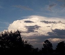
A pileus (/ˈpaɪliəs/; Latin for 'cap'), also called scarf cloud or cap cloud, is a small, horizontal, lenticular cloud appearing above a cumulus or cumulonimbus cloud. Pileus clouds are often short-lived, appearing for typically only a few minutes,[1] with the main cloud beneath them rising through convection to absorb them. Furthermore, the clouds are typically formed by drier air with a higher lifting condensation level, which often prevents vertical growth and leads to the smooth horizontal cap shape that the cloud is named for.[2]
They are formed by strong updraft at lower altitudes, acting upon moist air above, causing the air to cool to its dew point as it rises.[3][4] As such, they are usually indicators of severe weather, and a pileus found atop a cumulus cloud often foreshadows transformation into a cumulonimbus cloud, as it indicates a strong updraft within the cloud.[3][5]
Pilei can also form above mountains, ash clouds, and pyrocumulus clouds from erupting volcanoes.[6] Pilei form above some mushroom clouds of high-yield nuclear detonations.[7]
- ^ "UBC ATSC 113 - Pileus clouds". www.eoas.ubc.ca. Retrieved 2023-11-28.
- ^ "Pileus Clouds: smooth capping clouds". ww2010.atmos.uiuc.edu. Retrieved 2023-11-28.
- ^ a b Ulrike, Lohmann. An Introduction to Clouds: From the Microscale to Climate. Lüönd, Felix; Mahrt, Fabian. Cambridge. p. 288. ISBN 9781139087513. OCLC 953455396.
- ^ Garrett, T. J.; Dean-Day, J.; Liu, C.; Barnett, B.; Mace, G.; Baumgardner, D.; Webster, C.; Bui, T.; Read, W.; Minnis, P. (19 April 2006). "Convective formation of pileus cloud near the tropopause". Atmospheric Chemistry and Physics. 6 (5): 1185–1200. Bibcode:2006ACP.....6.1185G. doi:10.5194/acp-6-1185-2006. hdl:2060/20080015842.
- ^ "Facebook". www.facebook.com. Retrieved 2023-12-11.
- ^ Hamblyn, Richard (2017-05-15). Clouds. London. ISBN 9781780237701. OCLC 1000297560.
{{cite book}}: CS1 maint: location missing publisher (link) - ^ Holzmann, B. G.; Cumberledge, A. A. (October 1946). "Weather and The Atomic Bomb Tests at Bikini (II)". Bulletin of the American Meteorological Society. 27 (8): 435–437. Bibcode:1946BAMS...27..435H. doi:10.1175/1520-0477-27.8.435.