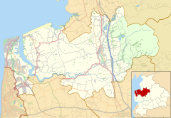
| Pilling | |
|---|---|
 St John the Baptist's Church, Pilling | |
Location within Lancashire | |
| Population | 2,020 (2011 Census) |
| OS grid reference | SD405485 |
| • London | 204 mi (329 km) SE |
| Civil parish |
|
| District | |
| Shire county | |
| Region | |
| Country | England |
| Sovereign state | United Kingdom |
| Post town | PRESTON |
| Postcode district | PR3 |
| Dialling code | 01253 |
| Police | Lancashire |
| Fire | Lancashire |
| Ambulance | North West |
| UK Parliament | |


Pilling is a village and civil parish within the Wyre borough of Lancashire, England. It is 6.5 miles (10.5 km) north-northeast of Poulton-le-Fylde, 9.4 miles (15.1 km) south-southwest of Lancaster and 14.5 miles (23.3 km) northwest of Preston, in a part of the Fylde known as Over Wyre.
The civil parish of Pilling, which includes the localities of Stake Pool, Scronkey and Eagland Hill, had a total resident population of 1,739 in 2001,[1] increasing to 2,020 at the 2011 Census.[2] Populations in the 19th century ranged from 1,281 in 1851 to 1,572 in 1871.[3]
- ^ "Parish headcount" (PDF). Archived from the original (PDF) on 10 December 2006. Retrieved 13 April 2008.
- ^ UK Census (2011). "Local Area Report – Pilling Parish (E04005335)". Nomis. Office for National Statistics. Retrieved 27 March 2021.
- ^ Our Country Churches and Chapels. A. Hewitson. 1872. p. 498.


