 | |
 | |
| Location | Gills Rock, Wisconsin |
|---|---|
| Coordinates | 45°17′3.067″N 86°55′11.012″W / 45.28418528°N 86.91972556°W[1][2] |
| Tower | |
| Constructed | 1858 |
| Foundation | Concrete |
| Construction | Milwaukee Cream City brick[5] |
| Automated | 1962 |
| Height | 41 feet (12 m)[3] |
| Shape | Square |
| Markings | yellow, black lantern and parapet |
| Heritage | National Register of Historic Places listed place |
| Light | |
| First lit | 1858 |
| Focal height | 48 feet (15 m)[4] |
| Lens | Fourth order Fresnel lens |
| Range | 12 nautical miles (22 km; 14 mi)[1] |
| Characteristic | White, Flashing (2), 6 sec[1] |
Pilot Island Light | |
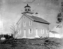
 USCG archive photo | |
| Nearest city | Gills Rock, Wisconsin |
| Area | 3.5 acres (1.4 ha) |
| NRHP reference No. | 83004279[6] |
| Added to NRHP | November 21, 1983 |
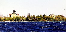
The Pilot Island Light is a lighthouse located near Gills Rock, on Pilot Island at the east end of Death's Door passage, in Door County, Wisconsin.
The building's design is similar to Pottawatomie Light on Rock Island (and many others), but is made of brick instead of stone. Until 1910 it was called Port des Morts Island Light. The light was converted to electric in 1942 and automated in 1962.[7]
- ^ a b c Light List, Volume VII, Great Lakes (PDF). Light List. United States Coast Guard. 2014.
- ^ Pilot Island Light in Lighthouse Resources: Historic Lighthouses & Light Stations, United States Coast Guard, October 1, 2019
- ^ Pepper, Terry. "Database of Tower Heights". Seeing the Light. terrypepper.com. Archived from the original on 2021-10-23. Retrieved 2009-10-04.
- ^ Pepper, Terry. "Database of Focal Heights". Seeing the Light. terrypepper.com. Archived from the original on 2022-03-03. Retrieved 2009-10-04.
- ^ Pepper, Terry, Seeing the light, Pilot Island. (Archived February 8, 2020)
- ^ "National Register Information System". National Register of Historic Places. National Park Service. March 13, 2009.
- ^ "Pilot Island Lighthouse". LighthouseFriends. Retrieved 2023-09-03.
