This article needs additional citations for verification. (March 2008) |
| Pindus | |
|---|---|
| Pindos, Pindhos | |
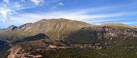
 Pindus in Epirus – The village of Anthochori resting beneath the east face of Kalogiros peak, Lakmos Mountain. | |
| Highest point | |
| Peak | Smolikas |
| Elevation | 2,637 m (8,652 ft) |
| Coordinates | 40°05′20″N 20°55′31″E / 40.08889°N 20.92528°E |
| Dimensions | |
| Length | 112 mi (180 km) north-south |
| Width | 35 mi (56 km) |
| Naming | |
| Native name | |
| Geography | |
| Countries | |
| Provinces/Counties | |
The Pindus (also Pindos or Pindhos;[1] Greek: Πίνδος, romanized: Píndos; Albanian: Pindet; Aromanian: Pindu) is a mountain range located in Northern Greece and Southern Albania. It is roughly 160 km (100 miles) long, with a maximum elevation of 2,637 metres (8652') (Mount Smolikas). Because it runs along the border of Thessaly and Epirus, the Pindus range is known colloquially as the spine of Greece. The mountain range stretches from near the Greek-Albanian border in southern Albania, entering the Epirus and Macedonia regions in northern Greece down to the north of the Peloponnese. Geologically, it is an extension of the Dinaric Alps, which dominate the western region of the Balkan Peninsula.
- ^ Latin form Pindus is used by Encarta Archived 2009-08-20 at the Wayback Machine. Both Pindus and Pindos are used by the Encyclopædia Britannica (here and here). It is the largest mountain range in Greece. Modern guidebooks tend to use Pindos (Baedeker's Greece, DK Eyewitness Travel Guide, Cicerone Mountain Walking) or Pindhos (Lonely Planet, Rough Guide).

