Pine Point | |
|---|---|
Abandoned locality/former town | |
 Pine Point, Northwest Territories, Canada | |
| Coordinates: 60°50′0″N 114°28′5″W / 60.83333°N 114.46806°W[1] | |
| Country | Canada |
| Territory | Northwest Territories |
| Region | South Slave Region |
| Census division | Region 5 |
| Constructed | 1962[2] |
| Incorporated (town) | April 1, 1974[3] |
| Dissolved | January 1, 1996[4] |
| Government | |
| • Type | Unincorporated (previously mayor-council government) |
| • Final mayor | Michael Lenton[5] |
| Time zone | UTC−07:00 (MST) |
| • Summer (DST) | UTC−06:00 (MDT) |
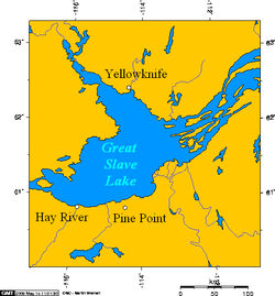
Pine Point is an abandoned locality that formerly held town status near the south shore of Great Slave Lake between the towns of Hay River and Fort Resolution in the Northwest Territories of Canada. It was built to serve the work force at the Pine Point Mine, an open-pit mine that produced lead and zinc ores. The town's population peaked at 1,915 in 1976, but was abandoned and deconstructed in 1988 after the mine closed in 1987.
- ^ "Pine Point". Geographical Names Data Base. Natural Resources Canada. Retrieved July 4, 2022.
- ^ Cite error: The named reference
Bonewas invoked but never defined (see the help page). - ^ Cite error: The named reference
Gazetteerwas invoked but never defined (see the help page). - ^ Cite error: The named reference
InterimListwas invoked but never defined (see the help page). - ^ Cite error: The named reference
PoPP3was invoked but never defined (see the help page).

